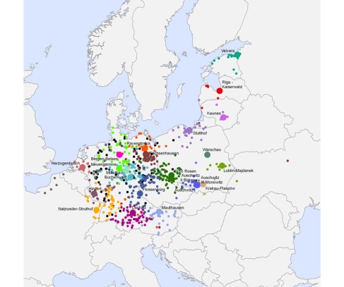
This week, Professor Ross wanted us to research and examine how GIS has played an important part in the field of Digital Humanities. GIS or Geographic information system is used to analyze and gather multiple different types of data concerning a geographical area. For example, you can use GIS to examine topology in specific areas, or how migration of peoples through different areas, and countries.
Professor Ross gave us a few examples of GIS scholars, including Anna Kelly Knowles. Her work has been primarily focused on World War 2 GIS projects that dealt with nazi concentration camps in Europe.
In this photo you can see GIS at work. The GIS map is plotting the concentration camps throughout Europe, as well as pointing out subcamps that were part of the SS. The map is within the timeframe of 1933-1945. It points out a vivid picture of how the Nazi Germany spaced on the concentration camp. Regarding a history field, this map reveals to scholars how the SS concentration camps manifested from Germany, and then spread out throughout the rest of Europe.
Regarding my project, I would like to add these specific maps to my database that Anna Kelly Knowles and other scholars have worked vigorously on to help paint a clearer picture of the atrocities of World War 2.
After realizing the potential of GIS for history, I continued to search for other scholars who have contributed to World War 2 history through GIS. As I searched, I stumbled upon an old GIS project that actually worked specifically wiith World War 2. if you look here, you can see the project was last updated in 2007. It seems that the GIS project was abandoned, and the GIS maps on the site don’t seem to properly work anymore. I was unable to find a name, or a specific university that funded the project. What the site did have was a link that took me to rich source of World War 2 primary and secondary sources. If you click this link, you can see the substantial about of research portals for World War history.
If you click the link specifically dealing with World War 2 maps, you will notice the substantial about of information being presented.
this map will appear. This strategic map dealing with the invasion of D-day was more in likely not created with a GIS program. Whats important is the information represented in the map, which can help create a GIS map regarding operation Overlord.
The GIS project started by unknown creators at least left a substantial amount of research information of the site, which will aid me in my own database project.
As I continued my search for GIS projects, I stumbled upon a few videos that used GIS mapping and historical pictures to show the liberation of Europe.
Overall, I feel that GIS projects upon a new door to understanding history. We can see the potential of digitization through these modes of information. I hope to use interactive maps, GIS maps, and even historical maps in my own project.
