Project Review: Anje Merkies

The project that Anje Merkies has been working on this semester is essentially a digitization of the substantial amount of cook books we have in the University of Guelph library. Anje wanted her project be educational and academic. After going through her website I believe she indeed met these goals.

To publish her researched information she used the University of Guelph publishing software, and used a template she found online to place her information. She recently posted a before and after of her website on her blog which can be found here. When you look at it you can tell she put a substantial amount of work into making the template unique and relevant to her cook book project. She mentioned that website design took a lot more time she anticipated due to having to learn code languages such as HTML and CSS.

Concerning the digitization of the books. Anje mentioned that she spent over 6 hours to scan all the images, and text from the large collection of cook books at the university. During her presentation she did not have all the books on the website, as I am going through it now it seems she has spent several more hours digitizing more books. The most compelling part of the site is her timeline page. Each book is properly placed in the published date and the citations are very descriptive. Each link to a specific cookbook has an image and a description of what the cook book instills. The majority of the books you click on offer a link to a PDF where you can view all the pages. This is incredible work, and I can tell she spent a lot of time working on this project.

Anje also included multiple other sections in her website. The website includes a blog where she posted a video of actually making one of the recipes. I thoroughly enjoyed watching the video, and seeing the recipe in a visual manner,  In the section labelled Data.  You can view more interesting information and research. Sub sections such as charts and graphs show you how many published books were in Canada and charts revealing which cities published more than others. Another section is mini essays where you can look at Anje’s own academic papers on the cookbooks. At the moment the links are not working, but hopefully they will be implemented.

The links page is a fantastic resource for all the websites, and other forms of media she used to gather her research.

Overall, fantastic project. I thoroughly enjoyed going through the website, and learning about how vast our collection of cookbooks was. This website is a great way to gain awareness for our schools collection. Again, great job!


Posted in About Me | Leave a comment

Fantastic review of my project by Jenna Helder

Jenna Helder

Kyle’s project was fantastic! I was really impressed with his website and twitter feed. His video clip/map was entertaining also, however I agree with the prof about the song choice, perhaps another would be good.

After exploring his site, I really liked the graphics and visual effects of the page. The transitions are very attractive, and the pictures keep the interest between the content. The content is great too, utilizing the primary sources to offer a glimpse into the daily lives of the regiment. His twitter feed is useful for dates and first person experiences. It is very evident that he did considerable research into this regiment, and that his source was highly informative.

I also really liked that he had his twitter feed subscribe button on his site in a very accessible location, available through each page. His home page is fantastic in that it offers a glimpse into…

View original post 97 more words

Posted in About Me | Leave a comment

Final Project Announcement

Image

Click the link provided to see my website: Royal Hamilton Light Infantry Regiment

Click the link provided to see the twitter feed: Personal journey within the RHLI

The animation map will be finished later tonight, and uploaded on the site!

I have finally completed the majority of my project. This last week has been quite busy with the amount of work I have encountered for my project. The website is finished, my twitter is up to date, and I am touching up my animation map. The map itself has been the heaviest section of my project, and I will be rendering the final version of it tonight.

For my project presentation on tomorrow I will be revealing all three of the components:

1) The Animation map of the RHLI’s campaign through Europe.

2) The accompanied twitter feed which outlined a personal journey of a solider part of the regiment through Operation Jubilee.

3) The website that outlines every major battle the RHLI encountered in Europe by incorporating personal accounts of the Riley’s that lived it.

Conclusion to my project:

This course has been an eye opener for me. It has revealed so many new programs, and various ways to incorporate old knowledge in a new modern approach. The online tutorials for programs like Adobe Aftereffects, Dreamweaver, Sony Vegas, Wix, Twitter, etc, can help any newcomer at creating something distinct and unique.

The process, and creation of this project was an incredible experience or me! I hope to continue with the history of the Royal Hamilton Light Infantry by expanding my site and maybe even researching into other Canadian regiments during World War 2. I hope the information present on my site, word press, twitter, and animation map will help create awareness for Canada’s contribution in World War 2, and specifically the sacrifices the RHLI made for a better tomorrow.

Posted in About Me | Leave a comment

Project Update. Twitter, and different outlets of knowledge.

Hello!

Creating a new post to discuss the new updates concerning my project.

I will be discussing four different aspects.

1) Website issues

2) Twitter Update.

3) New ways of obtaining knowledge

First of all, I have found that website design is a lot harder than I first imagined. After searching through the University of School private web publishing tool, I realized that it is quite out of date. Not only that, but our publishing tool is quite limited in scope when it comes to programs allowed to use. I tried using FileZilla, but the program requires a substantial knowledge in FTP coding. I moved on to Dreamweaver and actually had a lot more success. I used Dreamweaver a lot in highschool, so I had enough experience to fiddle around with the code and the tools of the program. Unfortunately, my knowledge is lacking when it comes to layout design. I couldn’t create anything that looked sub-par to websites that already present within the web. I looked around at other web site publishing tools and I ran into this website. Wix, is a free publishing tool that already has user-created free layouts. You take the layout and change the layout to your desired project. I’m going to use this tool for my website, because for now I just want to get the information in an organized manner.

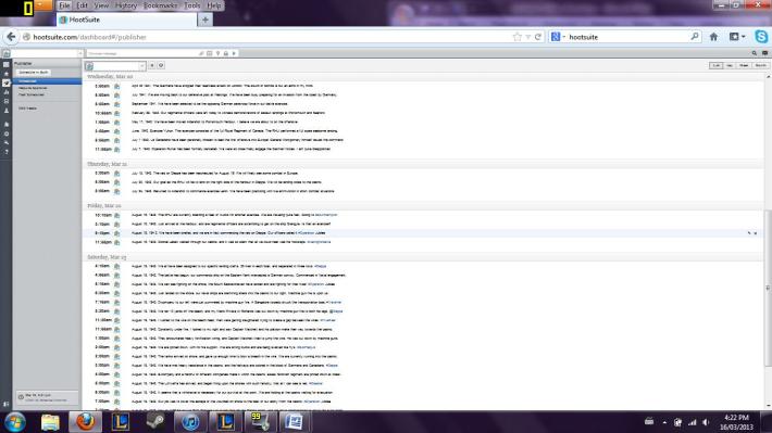
2) My twitter has been going quite well. In my last post, I showed images that organized my twitter posts in a specific schedule.

Image

In the image above you can see the organization hootsuite allows twitter users to do. I have organized all my tweets to properly portray the journey of the Royal Hamilton Light Infantry.

Feel free to check out my twitter page here: Royal Hamilton Light Infantry.

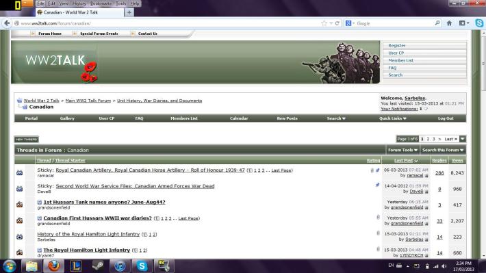
3) After running into issues regarding finding different sources on my topic. I went into new research outlets I haven’t before. I went to the World War 2 talk forum. This forum is incredible because it encompasses thousands of users who are all quite adept in the history of World War 2.Image

In the image above you see a few topics concerning the Royal Hamilton Light Infantry. I created the topic “A History of the Royal Hamilton Light Infantry” and i’ve had multiple people show interest in the topic. People within the forum replied to my thread, and have posted images, and gave me links to sources I wouldn’t have even considered. The internet is a beautiful thing, and if you find the right outlets the information you can obtain is endless.


Posted in About Me | Leave a comment

Project update!

Hello, I am reporting back from a strenuous and stressful week! Not only was I busy prepairing for my presentation which I believe was a complete success on tuesday! but I also had to write my fourth year history paper. Unfortunately, because of my conflicting class, I was unable to work to much on my project this week. I will be returning full force next week to deliver several new updates, and hopefully a published website.

What Ive done this week! For my fellow colleagues who was unable to make last weeks class, I have uploaded and create a youtube channel to view my animation map I’ve been working tirelessly on.

Click here to view the map!

The animation map is an interactive journey through the Royal Hamilton Light Infantry’s tour of World War 2.I am hoping that this animated map will encourage further awareness for Canadian’s contribution to World War 2. I also hope it might create and garner some knowledge for those are interested in looking into World War 2.

Concerning my website!

I lack any experience when it comes to creating a website. Next week starting Monday I am going to be looking into every aspect of website design, and hopefully I can figure out how to create one myself. I shall be looking into Omeka, and other website design programs to help assist me in this endeavor.

Concerning my twitter feed!

My twitter is now live and active! You can access my twitter with this link:

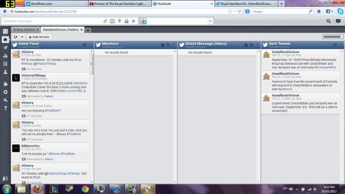
It will be updated frequently after I get everyone set up with the program HootSuite.

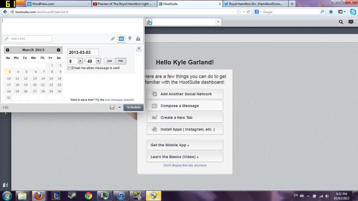
In the picture below, you can see that I’m currently making specific dates for twitter updates to automatically be posted. This will be a helpful tool because tweeting can be quite time consuming!

Image

Image

It is a remarkable and useful program!


That is the update so far! Looking forward to further delving into my project!

Posted in About Me | Leave a comment

R.H.I.R (Royal Hamilton Infantry Regiment) Project update..

Hello, I have arrived back from the relaxing, but eventful reading week to update the status on my project.

As highlighted in my last blog, I finally came up with a finalized idea. During the reading week I set myself a pretty large goal, “To complete my animation timeline map for the Royal Hamilton Infantry during World War 2.” I can say with my pride still in tact that I have not met that goal. BUT! I personally believe I made a large step towards completing it even with obstacles I faced.

First obstacle: I downloaded, and installed the YellowJacket software to begin my animation section of my project. The program titled, “Sting Editor” was a much more complicated tool then I first anticipated. After finishing a few tutorials, and rummaging through the tools of the software I unfortunately realized it did not have the visual integration I wanted. String Editor is fantastic to accomplish multiple educational projects across multiple fields of study, but I wanted to do something a little more visually appealing. The program lacked a zooming feature, and it presented a lot of boundaries where creativity was concerned. I wanted my animation map to be appealing, and educational. Unfortunately, string editor lacked the appealing aspect of my project. Don’t get my wrong, I found the String editor a very helpful tool, and I people creating animated maps to give it a go.

Solution to my obstacle: Instead of using Sting Editor, I went to a much more complicated program Adobe After-effects. I have years of experience with this program, but I first wanted to branch out to other programs such as Sting Editor. Using After-effects is a great way to animate objects, and used my thousands of professionals in advertising, Ad companies and several different business organizations. Whats great about After-effects is that it can be used for multiple different academic fields, and yes even History.

Here is my process thus far:

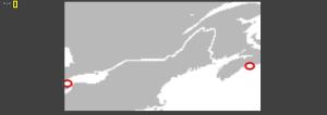
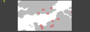
AfterFX 2013-02-23 21-33-59-23AfterFX 2013-02-23 21-34-08-87AfterFX 2013-02-23 21-34-24-86AfterFX 2013-02-23 21-34-31-21 The figure above shows a portion of Continental Europe. More specifically, it shows England, coast of France, and Belgium.

The dots represent Towns/bases/ports and cities where the Royal Hamilton Infantry traveled to during World War 2. Although it doesn’t look like much, every one of those dots is animated, and has programmed pathways for designated icons.

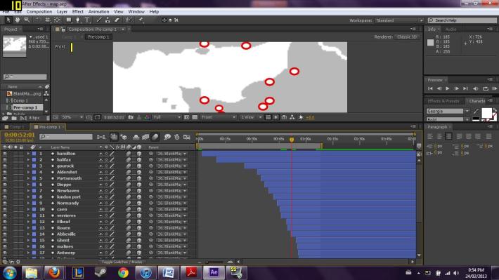
Image

As you see in the picture above, there are several different pathways assigned for each city. Will not lie, this took a substantial amount of time, but it was a great experience.

As I write this blog I am working on this map. I hope to have a fully rendered preview of my map for my project proposal on Tuesday!

See you in class!

Posted in About Me | Leave a comment

By Jolly, I think I got it!

After several days of reading through the comments and suggestions, I have finally come up with a concrete project idea. After today’s class discussing social media, I further researched the idea of educational approaches to a broader audience through different mediums.

To elaborate, I personally feel that general knowledge of World War 2 history has been neglected in both high school and universities. I was considering why that is, and it really all comes down to awareness. Plenty of youth, and students are unaware of specific facts about the subject. I understand that history in itself is a very hard subject to teach to youth, but I am hoping if I open a few new mediums with the digital world, that I can metaphorically open a whole new door for the topic of military history.

Concerning social media, I felt that one of the most prominent forms of digital interaction was through the social website twitter. In class we discussed, and learned that even specific modes of history have actually used twitter effectively. Specifically  we looked at the World War 2 twitter feed that posts facts, and stories concerning military history.

You can see examples of these:

1941 World War 2

World War 2 History 

World War 2 Today

As you can see there is already plenty of these twitter feeds contributing to the history of World War 2. These are quite educational in that sense that they are small quantities of information that people might be interested in. Say I post a tweet concerning a specific causality list in The Battle of the Bulge, a twitter follower might be prompted to look further into the battle and find additional information about it.

Concerning my project:

I want my personal project to be educational, which will help gain awareness for World War 2 history, and promote a more diverse Canadian perspective. 

This is my project in 3 steps:

1) I want my project to promote more awareness on Canadian involvement in World War 2.  To do this, I am going to follow The Royal Hamilton Light Infantry through their tour of Europe. I picked this battalion because it feels close to home, and it is one of only battalions that were a part of operation Dieppe, and operation Overlord. 

I am going to use report documents, and primary sources to get an accurate portrayal of what they encountered during their European campaign.

2) During the process of researching the The Royal Hamilton Light Infantry, I am going to include a mapping portion to my project. Using this program found here: Animating history. I am going to include an accurate representation of how the battalion moved during the war. I am hoping this will give a more national appreciation of our Canadian Contribution in World War 2.

3) The last segment of my presentation will specifically deal with twitter. I am going to create a The Royal Hamilton Light Infantry twitter page, where followers can actively see updates of the battalions journey through World War 2. I am going to use historical facts, but I will be creating an anonymous solider who will detail his experience in the regiment. Tweets will range from historical facts about training, to tweets about the weather, battle strategy, and emotions a solider might have felt during a firefight. 

With these three compenents I hope I can make a very resourceful, fun and educational project to gain awareness for the general history of World War 2, and more specifically Canadian pride for our involvement during World War 2.

Posted in About Me | 2 Comments

Project brainstorming

Organizing and considering a project for the Digital Humanities is no simple task. I have been brainstorming, and thinking about a manageable project for the overwhelming amount of history surrounding World War 2.

First, I wanted to create a large database for World War 2 history nuts like me and others. But, as I searched I realized how naive I was to even consider being able to create a database surrounding the mountain of information that is World War 2. I wanted to create a database which could reflect the history of World War 2 in a non bias fashion. I was hoping to combine primary and secondary sources from every perspective of the war to create a better understanding of specific events that occurred. Doing this would take years of work, and It is ignorant to suggest that myself could do it alone.

Since my passion for World War 2 history is still unharmed, I do wish to continue doing a project with something surrounding World War 2. After going through the GIS tutorial and learning the way around Google Earth, it got me thinking with a new lens.

1) I could still create an online database of World War 2 history, but I would have to be a lot more specific. What I hope to do is pick significant battles and operations that took place in European front, and contribute the different countries perspective regarding those battles. For instance, I could include Operation Barbarossa and the sources surrounding the event. I can include both the German perspective, and the Russian perspectives like I previously wanted to in my first ideas. This way, it would be much more specific and it is something I could do in a shorter time frame. With Google Earth, I could illustrate where exactly these events occurred, the battle strategy, and how it actually played out.

2) I could create a small database. Figure out the complexities of building a site, and just databasing specific Battles of World War 2.

Those are my ideas thus far.

Let me know if you think these ideas seem logical or even possible.

Posted in About Me | 5 Comments

Assignment #3 GIS research. (World War 2 Project)

This week, Professor Ross wanted us to research and examine how GIS has played an important part in the field of Digital Humanities. GIS or Geographic information system is used to analyze and gather multiple different types of data concerning a geographical area.  For example, you can use GIS to examine topology in specific areas, or how migration of peoples through different areas, and countries.

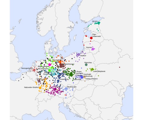
Professor Ross gave us a few examples of GIS scholars, including Anna Kelly Knowles. Her work has been primarily focused on World War 2 GIS projects that dealt with nazi concentration camps in Europe.Image

In this photo you can see GIS at work. The GIS map is plotting the concentration camps throughout Europe, as well as pointing out subcamps that were part of the SS. The map is within the timeframe of 1933-1945. It points out a vivid picture of how the Nazi Germany spaced on the concentration camp. Regarding a history field, this map reveals to scholars how the SS concentration camps manifested from Germany, and then spread out throughout the rest of Europe.

Regarding my project, I would like to add these specific maps to my database that Anna Kelly Knowles and other scholars have worked vigorously on to help paint a clearer picture of the atrocities of World War 2.

After realizing the potential of GIS for history, I continued to search for other scholars who have contributed to World War 2 history through GIS. As I searched, I stumbled upon an old GIS project that actually worked specifically wiith World War 2. if you look here, you can see the project was last updated in 2007. It seems that the GIS project was abandoned, and the GIS maps on the site don’t seem to properly work anymore. I was unable to find a name, or a specific university that funded the project. What the site did have was a link that took me to rich source of World War 2 primary and secondary sources. If you click this link, you can see the substantial about of research portals for World War history.

If you click the link specifically dealing with World War 2 maps, you will notice the substantial about of information being presented.

this map will appear. This strategic map dealing with the invasion of D-day was more in likely not created with a GIS program. Whats important is the information represented in the map, which can help create a GIS map regarding operation Overlord.

The GIS project started by unknown creators at least left a substantial amount of research information of the site, which will aid me in my own database project.

As I continued my search for GIS projects, I stumbled upon a few videos that used GIS mapping and historical pictures to show the liberation of Europe.

Overall, I feel that GIS projects upon a new door to understanding history. We can see the potential of digitization through these modes of information. I hope to use interactive maps, GIS maps, and even historical maps in my own project.


Posted in About Me | Leave a comment

Assignment #2 Orlando Project.

Orlando_tree-_blue_transparentImageThe Orlando Project is a wo

men’s literature database on the internet the specifically deals with women writing in Britain. It encompasses over 1,200 writers including both female, and male authors. The database is continually growing and expanding into more directions concerning lost authors, or more obscure authors that often hard to find context for. The database is extremely helpful for scholars in the literature field who are seeking sources in women’s writing in Britain. It has plenty of sources to choose from, with a very complex search engine. As stated in my last assignment, I stressed the importance of narrow-vision when it comes to searching for specific sources. ORLANDO has

multiple functions that allow you to be very specific in the fields you are interested in.  For example..

In the above image you can see that the search engine is based off ‘Tags’. These tags are put on specific files, and authors to maximize search results.

Again, in the above image you can see I have selected the parameters what “influences her” which contains the author “Margaret Atwood”

Now you can see the finals results which I highlighted in this screenshot. You can see that only a few search results have appeared because of the narrow search. This is just a practice, but it reveals that Edna O’brian indeed was influenced by multiple authors, which included Margaret Atwood.

This database was shown to us by Professor Susan Brown. She has a significant role in the research collection, and site administrating for ORLANDO. Seeing a database like this, gives me insight in how I can go about looking at doing my project regarding a World War 2 database. If I can understand the MARK programming used, and how I also could categorize the results, I could began to understand how to structure my own.

Posted in Assignments | Leave a comment